Archives
Enter a word or phrase to perform a general search across all records in the Archives catalog. You can also browse records in the catalog without performing a search.
Search Tips
- Searches are not case sensitive.
- Searching for multiple words connects them with OR by default. Matching records can contain any of the words.
- Connect multiple words with AND if you only want to see records containing both words.
- Use quotation marks to search for a phrase.
- Place an asterisk (*) at the end of a word as a wildcard.
240 results found. Records searched: 240
-
Permanent Collection - 1997.23
Photocopy of a street map of Winnetka drawn by Frank A. Windes showing location of all homes in the Village in 1896. Original is at Village Hall.
Record Type: Archive
-
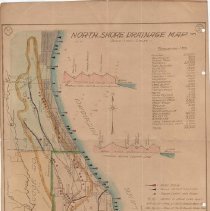
Permanent Collection - 1997.58
Map by Windes & Marsh of North Shore drainage in the North Branch of the Chicgo River water shed, showing water intakes and sewer outlets. The area covered runs from Chicago's north side to Waukegan and west to the DesPlaines River. The map includes elevation profiles (1) along Chicago north city limit, (2) along the Cook/Lake County line, and (3) from Lake Bluff to Libertyville. The population of the communities in the covered area is listed ...
Record Type: Archive
-

-
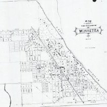
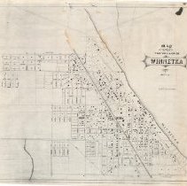
Permanent Collection - 1999.21.1-4
Map of the Village of Winnetka in 1896 drawn by Frank A. Windes, showing street names, layout of street blocks and location of buildings. "Notation: "F.H.E No - Sup. Public Works." Original (.01) and 3 copies (.02-.04)
Record Type: Archive
-
Permanent Collection - 1999.87.1-4
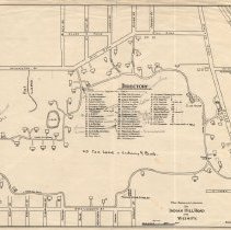
1) March 1935 map of Indian Hill Road area showing the location and owners of various properties on Indian Hill Road and a few surrounding streets. Penciled changes in ownership of properties have been noted as of an unknown date. 2) Undated map of Woodley Road and Associated Properties, including Indian Hill Subdivision No. 5, showing lots and owners thereof. Acreage is given for some lots not owned. Prepared for Richard B. Hart, 135 South L...
Record Type: Archive
-
Permanent Collection - 2000.104.2
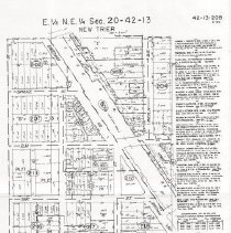
Photo copy of plat map for E1/2 NE1/4 Sec 20-42-13 prepared by The Sidwell Company. The map covers the area bounded by Willow Road on the south, Birch Street on the west, Pine Street on the north and Ridge Ave/Lincoln Street on the east. The map shows streets, subdivisions, lots and the sizes thereof. On the right of the map is a description of the subdivisions and condominiums shown on the map.
Record Type: Archive
-
Permanent Collection - 2000.106.1
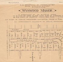
Map of Wynwood Manor Subdivision prepared by C. A. Hemphill & Associates, 3935 Simpson Street, Evanston. The map shows 22 building sites on the east side of Hibbard Road, facing either Sunset Road or Lindenwood Drive/Apple Tree Road. The lot sizes are given along with the price, which ranges from $7,500 to $9,000. "North Shore Realty, 604 Green Bay, Kenilworth 323" is hand written on the left edge.
Record Type: Archive
-
Permanent Collection - 2000.86.1
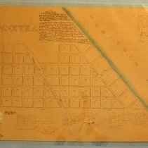
A copy of the plat of survey made in 1855 and recorded in 1858 of the original Winnetka subdivision owned by Charles & Sarah Peck, dividing the property into 71 lots. The dimensions of each lot are given. The streets are unnamed but run from the lake to west of the railroad tracks. Also has additional affidavits and notes made in 1858,1873, 1882 & 1926, including a history written by Carlton Prouty on June 1, 1926 describing how the plat was us...
Record Type: Archive
-
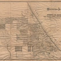
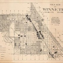
Permanent Collection - 2004.17.01
Map of Winnetka from 1903, mounted on a cloth backing, drawn by C.O. Axell and copyrighted by Frank A. Windes for use by Everett W. Osgood, real estate, loans and Insurance, LaSalle Street, Chicago. The map shows the corporate limits of the village, streets, lots, subdivisions, railroads, marshes, rivers, public parks and certain public buildings.
Record Type: Archive
-
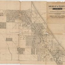
Permanent Collection - 2004.26.01
Map of Winnetka, Illinois, showing subdivisions, streets, lots, lot sizes and the location of public schools. It covers the area from Lake Michigan on the east, Winnetka Avenue on the south, New Trier Township limit on the west, and Jackson/Woodland Streets (Glencoe) on the north. The map was printed for Murray & Terry, 40 No. Dearborn, Chicago. There are a few pencil notations on the map regarding certain properties.
Record Type: Archive
-
Permanent Collection - 2005.00.68
Map of Chicago Industrial Sites at 47th and California
Record Type: Archive
-
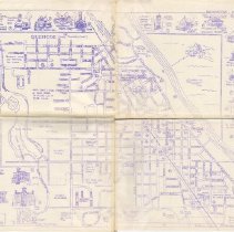
Permanent Collection - 2005.00.71
Map of Winnetka identifying the location of 55 historical points of interest in the Village. Prepared by Barbara Beatty. Sketches of some of the historical buildings included as points of interest are displayed around the edge of the map.
Record Type: Archive
-
Permanent Collection - 2007.21.01
1939 reprint of 1928 edition of USGS map of the Evanston Quadrangle (North Shore area). From Rogers Park in Chicago at south end, north to south Glencoe; from lake at east, to Highway 41 and Skokie Marsh at west. Shows location of streets and buildings throughout the area.
Record Type: Archive
-
Permanent Collection - 2007.21.02
1976 zoning use district map of Winnetka published by the Village. Shows distribution of residential (by acreage of 1/2, 1/3 and 1/6 acres), commercial, and industrial zoned areas in village as provided by the zoning ordinance as amended through February 26, 1968. This is the same map located at FIC2016.24.
Record Type: Archive
-
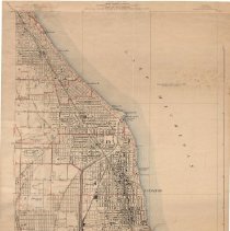
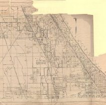
Permanent Collection - 2010.13.04
Map of the North Shore, from Central St., Evanston on the south to County Line Rd. on the north; from the lakeshore on the east to Pfingsten Rd. on the west. Drawn by Ida S. Randall from Windes & Marsh. Includes parts or all of Evanston, Wilmette, Kenilworth, Winnetka, Glencoe, Glenview, Northfield, and Northbrook. Shows mostly completed Skokie Lagoons, and Curtiss-Reynolds airport in Glenview (before it became Glenview Naval Air Station). Th...
Record Type: Archive
-
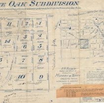
Permanent Collection - 2010.13.05
2010.13.05.01: Map of the White Oak subdivision in Winnetka, between Willow Rd. and Sunset Rd., west of Birch St. A private way (later named White Oak Lane) runs through the subdivision, as do several smaller private ways going east/west. The subdivision is divided into 16 lots, acerage and dimensions are given. The names of some buyers, sale dates and prices are written in pencil. A slip of paper in the lower right gives the prices of certai...
Record Type: Archive
-
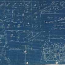
Permanent Collection - 2010.13.06
2010.13.06.01: Blueprint map of a proposed subdivision southeast of Hibbard Rd. and Hill Rd. and west of Locust Rd., with West, South and East Woodley Roads running through the subdivision (subdivision was never recorded). The map shows 33 lots and gives dimensions and acreage. Some lots show the names of owners; others have "sold" or "blt." written on them. An inset on the lower right shows the location of the subdivsion in relation to the re...
Record Type: Archive
-
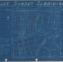
Permanent Collection - 2010.13.07
Blueprint map of Alles' Sunset Subdivision, bordered by Glendale Avenue on the west, Willow Road on the north, private road (an extension of Sunset Road) on the south and property line on the east (which is an extension of Locust Street north of Willow Road). The map shows 82 lots included in the subdivision and gives their demensions. Water, sewer, electricity and gas information about the subdivision is written on the map. Map is glued to a l...
Record Type: Archive
-
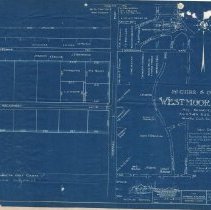
Permanent Collection - 2010.13.08
2010.13.08.01: Blueprint map of McGuire and Orr's Westmoor Acres subdivision, west of Hibbard Rd. between golf course and Westmoor Rd. Drawn by Windes and Marsh for McGuire and Orr, 530 Davis Street, Evanston, Ill. Map gives a description of the subdivision of 10 homesites off Hackberry Lane and shows names of owners of existing homes in and around the subdivision. The map states it is "Not Recorded." 2010.13.08.02: Small flyer by McGuire ...
Record Type: Archive
-
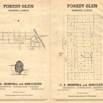
Permanent Collection - 2010.13.09
Two maps of various areas of Winnetka: 2010.13.09.01 (1) Large brochure for the Forest Glen subdivision in Winnetka, bounded by Asbury Ave., Tower Rd., Randolph St., and Euclid Ave. Developed by C.A. Hemphill and Associates, Evanston, Illinois. Brochure has map of the area and map of the subdivision the lots and the lot sizes. Map is glued to a ledger book page. 2010.13.09.02 (2) Large map of northwest Winnetka glued to the back of ledger pag...
Record Type: Archive
-
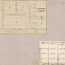
Permanent Collection - 2010.13.10
Small map of three Winnetka subdivisions: (1) Broadmeadow Properties subdivision, located north of Hill Rd., between Hibbard Rd. and Apple Tree Rd. Map shows lots for sale and names of several purchasers. Prices and lot size given. (2) six lots in the Indian Hill Club 3rd Fairway subdivision. Lot size and the name of one purchaser given. Maps are glued to the front of a ledger book page. On back of ledger book page is is glued a map of: (3...
Record Type: Archive
-
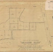
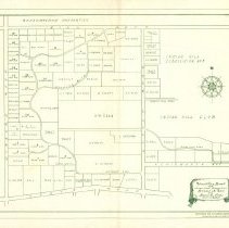
Permanent Collection - 2010.13.11
Map of Meadow Glen subdivision, located between Hill Rd. (north), Indian Hill Rd. (south), west of Church Rd. Shows 10 lots for sale and gives their lot size. Small price list for the lots, dated March 21, 1946, is stapled to the top right corner of the page. Map is glued to a ledger book page.
Record Type: Archive
-
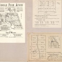
Permanent Collection - 2010.13.12
Three maps and a price list glued to a large ledger book page. Flyer with map of Middle Fork Acres subdivision, located west of Happ Rd., north of Willow Rd. in Northfield. Advertised by English Walling, 81 West Monroe Street, Chicago as a restricted subdivision (one of the restrictions listed reads "only persons of the Caucasian race may own, lease, occupy or use any of the said tracts, except servants."). Price list for lots in Middle Fork A...
Record Type: Archive
-
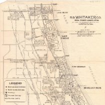
Permanent Collection - 2010.23.1
1939 Map of Winnetka and the North Shore published by R.B. Whitaker Co. of Winnetka. One side features a map of the North Shore from (south) Howard Street in Chicago, and pictures Evanston, Wilmette, Kenilworth, Winnetka, to the top of the Glencoe Village limits and Cook County line north. Lake Michigan is the eastern boundry, and the map goes as far west as Harlem Ave. and Waukegan Road. The opposite side features a south boundary at the Lake C...
Record Type: Archive
-
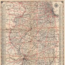
Permanent Collection - 2011.14.5
One folded 1934 Official Map of Illinois Highways issued by Edward J. Hughes, Secretary of State. On one side is a map of the state of Illinois with roads, cities and towns noted. Major roads are marked in red. An index of cities and towns is also provided, along with their population. On the reverse side is an inset of a map of Chicago and Vicinity showing streets and roads, and boxes giving Driving Safety suggestions and a Synopsis of the M...
Record Type: Archive
-
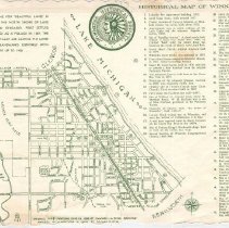
Permanent Collection - 2011.14.7
One placemat from the Indian Trail Restaurant featuring an Historical Map of Winnetka, Illinois labeled with trivia and locations of 42 noteworthy sites and landmarks. "Original map & locations made in 1938 by F.A. Windes & Peter Gerhand, Revised with Additions in 1963 by Samuel S. Otis." The Winnetka Historical Society logo is displayed on the placemat.
Record Type: Archive
-
Permanent Collection - 2011.16.01
Alles' sunset Subdivision map, drawn by Windes & Marsh, April 5, 1926. Map includes the area bounded by Willow Road to the north, Sunset Road / Private road to the South, Glendale Ave to the west, and approx. Locust Street to the east. Notes written in red pencil on the map.
Record Type: Archive
-
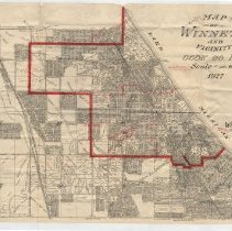
Permanent Collection - 2011.16.02
Winnetka and vicinity map by Windes & Marsh, 1927. Map includes the area bounded by Jackson/Woodlawn Aves (Glencoe). to the north, Lake Ave. to the south, Lake Michigan to the east, and Sunset Ridge Rd. to the west. Red line indicating Winnetka village limits has been drawn in, along with red lines to indicate the school district boundaries for the village. The map shows subdivisions, streets, lots, lot sizes. "J. B. Thomas & Co, 743 Elm St.,...
Record Type: Archive
-
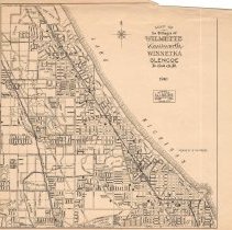
Permanent Collection - 2011.30.01
Map of the villages of Wilmette, Kenilworth, Winnetka, and Glencoe. Produced by the office of D.J.L Walther, civil engineer in Wilmette, 1932.
Record Type: Archive
-
Permanent Collection - 2011.30.02
Map of the Manus Indian Hill subdivision. Subdivision Subdivision is bounded by Winnetka Ave. to the north, Meadow Rd. to the south, Center St. (now Green Bay Rd.) to the east, and Ridge Rd. to the west. Map includes lot prices.
Record Type: Archive
-
Permanent Collection - 2013.07.10
Subdivision map of Woodley Road and Associated Properties by Richard B. Hart. The boundaries depicted are Hubbard Road to the west, Avoca road to the south, Locust Road to the East, and Hill Road to the north. Shows the owners of sold lots and the acreage of unowned lots.
Record Type: Archive
-
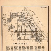
Permanent Collection - 2013.07.11
Map; Winnetka, printed by Sidwell Studio/Clear View Maps, Lombard, Illinois in 1946. In the upper half of the page, a simple map of Winnetka appears, with streets and numbered blocks. In the lower half, a list of roads in alphabetical order.
Record Type: Archive
-
Permanent Collection - 2013.07.12
Map of the Villages of Wilmette, Kenilworth, Winnetka, Glencoe, D.J.L. Walther, Wilmette, Ill., 1941. Map of North Shore communities, showing streets, school locations, train stations, parks and country clubs.
Record Type: Archive
-
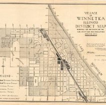
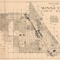
Permanent Collection - 2013.07.13
Map, "Village of Winnetka Illinois District Map," January 2, 1935. Shaded areas of the map shows the districts for the use, height and area regulations as provided in zoning ordinances as amended through January 2, 1935. Legend for the shading in the lower left corner for residential (1/2, 1/6 and "B" acres), commercial and industrial use.
Record Type: Archive
-
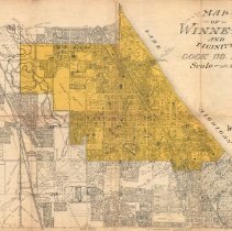
Permanent Collection - 2013.07.14
Map of Winnetka and vicinity prepared by Windes & Marsh, Winnetka. Area shown extends from Lake Michigan on the east to Sunset Road on the west, Lake Street on the South to Jackson/Woodlawn on the north. Winnetka is colored in yellow. The map shows streets, subdivisions, lots, lot sizes. Extensive handwritten notes on reverse regarding various lots.
Record Type: Archive
-
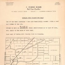
Permanent Collection - 2013.07.16
Map/Notice, "Woodley Road Vacant for Sale," J. Clarke Baker, real estate consultant, 30 North LaSalle Street, Chicago. Notice from real estate consultant J. Clarke Baker advertising vacant lot for sale. Map in lower half showing Woodley Road area with owners of sold lots and acreage of unsold lots.
Record Type: Archive
-
Permanent Collection - 2013.07.17
Subdivision map of Woodley Road by Richard B. Hart and Roger R. Shaw, 135 South LaSalle Street, Chicago, 1938. Similar to 2013.07.10. Shows the Woodley Road area bounded by Hill Road, Hibbard Road, Avoca Road and Locust Road, with the location of lots, owners of sold lots and acreage of unsold lots.
Record Type: Archive
-
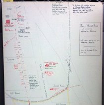
Permanent Collection - 2013.09.1
"Map of Church Road and environs, Winnetka, Illinois. With some geological and historical details. Drawn by Annette B. Peck May 1976." Inludes historical facts ranging from 50,000 BCE to 1916 assembled from research conducted by Annette B. Peck.
Record Type: Archive
-
Permanent Collection - 2015.05.02
Village of Winnetka District Map showing the use districts provided by Village ordinance passed and approved January 17, 1922, as amended to and including February 26, 1968. The map is shaded to show the location of the various residential, commercial and industrical use disctricts, with a legend located in the lower left. The map also shows streets, schools, public buildings, churches, and parks, along with the house numbering system.
Record Type: Archive
-
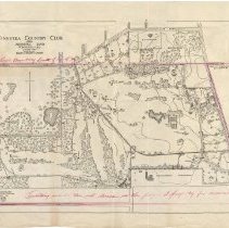
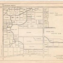
Permanent Collection - 2016.10.07
Map; Winnetka Country Club, now known as Indian Hill Country Club. The map shows the location of tees, greens, tennis courts, club house, etc., as well as lots around the club property in the area bordered by Winnetka, Hill and Alles Roads on the north, Church Road on the east, Locust Road on the west and Kenilworth Ave on the south. Most of the area covered by the map is outlined in red and the following notation is written on the map: "Terri...
Record Type: Archive