
Archive Record
Images
Metadata
Collection |
Burnham Family Collection |
Catalog Number |
2005.26.769 |
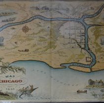
Scope & Content |
Colored, illustrated map of Chicago. Reproduction from 1933 of an historic map of Chicago about 1833. Belonged to Anita Willets Burnham. The map shows the town, then with a population of 350, located at the junction of the branches of the Chicago River. Includes street layout, historic buildings and the location of roads and trails going out from the town. Some historical information is provided, along with drawings of various buildings. |
Title |
Map of Chicago Incorporated as a Town August 5, 1833 |