
Archive Record
Images
Metadata
Collection |
Permanent Collection |
Catalog Number |
1988.279.09 |
Scope & Content |
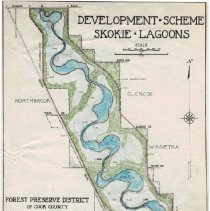
Map of the "Development Scheme Skokie Lagoons" published by the Forest Preserve District of Cook County. The map, in color, shows the Skokie Lagoons from Dundee Road on the north, Glencoe/Winnetka boundaries on the east, Willow Road on the south and Skokie Blvd. on the west. The lagoons and related flood plains are colored in blue, woodlands in green and the east and west diversion ditches in red. The location of dams, flood plains and dikes are shown, as is the location of the CCC Camp. The names of the Forest Preserve Board and the General Supt. are listed. This is a larger, colored version of the map at 1976.59.10. |
Title |
Development Scheme Skokie Lagoons |