
Archive Record
Images
Metadata
Collection |
Permanent Collection |
Catalog Number |
1996.121.2 |
Scope & Content |
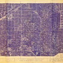
Floodplain Topographic Map North Branch of the Chicago River Lake and Cook Counties, Illinois. Sheet NB-21. Topographic lines on aerial photograph of Winnetka. Prepared by Alster and Associates, Inc. Madison, Wisconsin. Date of photography April 1972. Date of mapping Summer 1972. Prepared for U.S. Department of Agriculture Soil Conservation Service in cooperation with Metropolitan Sanitary District of Greater Chicago. Copy of 1996.121.1. |