
Archive Record
Images
Metadata
Collection |
Permanent Collection |
Catalog Number |
1992.86 |
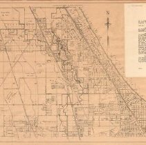
Scope & Content |
Map of the Chicago North Shore area covering the area from Lake Michigan on the east, Central Street, Evanston on the south, Pfingsten on the west and County Line Road on the north. It was drawn by Ida S. Randall and copyrighted by Windes and Marsh. Shows streets, railroads, rivers, golf clubs, airports, etc. It has attached a card advertising "Westmoor Acres," McGuire & Orr Inc. as well as a letter to J. Fred McGuire, dated November 11, 1938 and signed by Don Marsh of Windes & Marsh, explaining the problems causing the Skokie Lagoon flooding of July 1, 1938 and the flood control affecting Westmoor Acres undertaken as the result of the flooding. Map points out the location of Westmoor Acres subdivision and "Butler Lake." This is similar to Map # 2010.13.04. |
Creator |
MARSH, Don E. |
Title |
North Shore Map |