
Archive Record
Images
Metadata
Collection |
Permanent Collection |
Catalog Number |
1976.59.12 |
Scope & Content |
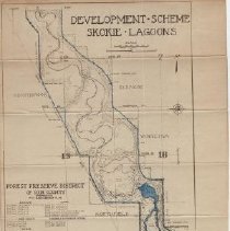
Map of the Development Scheme of the the Skokie Lagoons from Dundee Road South to Glenview Road, showing sections of Northbrook, Glencoe, Winnetka, Northfield, Wilmette, and Glenview. Similar to but less detailed than the map at 1976.59.11. Some areas of the map colored in with a blue pencil. Plots the locations of dams, dikes, flood plains, bridges, river beds, the river, channels and diversion ditches, roads, and the Skokie Valley Park CCC Camp, including barracks, the National Park Service E.C.W. Headquarters and U.S. Army Headquarters. Published by the Forest Preserve District of Cook County. |
Title |
Development Scheme Skokie Lagoons |