
Archive Record
Images
Metadata
Collection |
Permanent Collection |
Catalog Number |
1989.2037 |
Scope & Content |
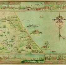
Historical Map of Winnetka, 1830 to 1934. Incorporated in 1869, compiled from records by Frank A. Windes, Winnetka Engineer, 1934. Map designed by Frank A. Windes, delineated by Ida S. Randall on April 3, 1934. Handcolored, framed, actual map size 32.13" x 22.15" Copyright Frank A. Windes, April 1934. Features a drawn map of Winnetka in 1934 marking important historical places with illustrations. A full-size reproduction was made and framed in a similar frame with glass. This reproduction was scanned for reprinting in 2014 to sell in the Winnetka Historical Society online shop and at events. |
Creator |
WINDES, Frank A. and RANDALL, Ida S. |
Title |
Historical Map of Winnetka |