
Archive Record
Images
Metadata
Collection |
Permanent Collection |
Catalog Number |
2778 |
Scope & Content |
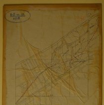
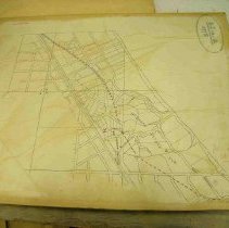
Map of Hubbard Woods mounted on board. The map shows the Hubbard Estate Subdivision and the Gilbert Hubbard Subdivision divided into lots, covering the area from Tower Road on the south, Lake Michigan on the east, the Railway on the west and an undentied street (probably Woodlawn) on the north. The map also covers the area north of the subdivsions extending into Glencoe. Sheridan Road and Green Bay Road (now Old Green Bay Road) are identified; otherwise no streets are named. Marked in pencil is the residence of L. D. Taylor and Anson S. Taylor. An unidentified broken red line runs from the southeast corner of the map to the northwest corner, following GreenBay Road the last half of the way. Several areas of marsh are noted in green on the map. |
Title |
Map of Hubbard Woods |