
Archive Record
Images
Metadata
Collection |
Permanent Collection |
Catalog Number |
3117 |
Scope & Content |
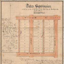
Plat of survey for John Dale's first Winnetka subdivision. The land is in the northeast 1/4 of the northeast 1/4 of the southeast 1/4 of Section 20, T 42, R 13; an area bound by Willow St, Hazel St, Mount Pleasant Ave, and Linden St. The subdivision has been divided into 36 lots; dimensions are given. The document is signed on behalf of the county surveyor by the deputy surveyor, the justice of the peace, and Winnetka village clerk. On the reverse side is the signature of the Cook County Recorder, showing a recording date of April 5, 1873. The plat is affixed to a cloth backing. (See Object ID 3116 for a subsequent 1879 subdivision of this same parcel.) |
Title |
Dale's Subdivision of the NE 1/4 of the NE 1/4 of the SE 1/4 of Section 20, T. 42, R13, Winnetka |