
Archive Record
Images
Metadata
Collection |
Permanent Collection |
Catalog Number |
3517 |
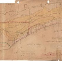
Scope & Content |
Map from 1910 showing water sheds west of North Shore suburbs with sites of septic tanks, sewer outlets & water intake. Water shed area colored yellow. Several areas are outlined in red or green. The map area covered extends from Chicago on the south to Waukegan on the north, Lake Michigan on the east to the DesPlaines River on the west. An inset shows elevation profile along the Lake/Cook County line from Lake Michigan to the DesPlaines River. A business card of Frank A. Windes, Civil Engineer, Winnetka is included. |
Creator |
Windes & Marsh |
Title |
Plat Showing Water Sheds West of North Shore Suburbs |