
Archive Record
Images
Metadata
Collection |
Permanent Collection |
Catalog Number |
1988.152.01-.03 |
Scope & Content |
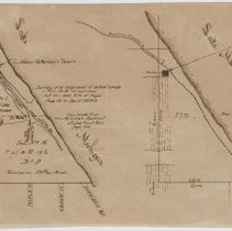
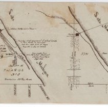
Map sketches (two copies) and one negative showing a triangular section of land in northeast Winnetka bordered by Lake Michigan on the east, Tower Road on the north, and Pine Street on the south. The west boundary is undefined but would be roughly Prospect Avenue. Written on the map is "Survey and approval of school lands in Twn 42 R 13 recorded Oct. 14, 1859 B.H. of Maps page 182 as Doc. No 24743. Copy made from Win Park Dist Abstract Lake Front Park Sept 1905" The map is divided into two parcels aggregating 57.91 acres and shows the location of Widow Patterson's Tavern and the Patterson Cabin. |
Title |
Map of Location of Patterson Tavern and Cabin |