
Archive Record
Images
Metadata
Collection |
Permanent Collection |
Catalog Number |
1988.167 |
Scope & Content |
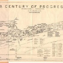
Map of the "Century of Progress" 1933 World Fair (May 27 - October 31, 1933). The map, with coordinates, shows the layout of the fairgrounds, including the location of buildings, surrounding streets, railroads, airstrips, streetcars, bus depots and boat landings. An alphabetically arranged legend gives the coordinate key for various sites. The map folds up into a paper cover. |
Title |
Huls' Alphabetically Keyed Map A Century of Progress |