
Archive Record
Images
Metadata
Collection |
Permanent Collection |
Catalog Number |
4131 |
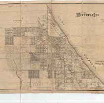
Scope & Content |
Map of Winnetka, including street names, acreage, subdivision sites and lot numbers. The map is mounted on cloth. There are a few handwritten notes on it giving acerage of some locations and price per acre. The maps states that it was compiled from records and surveys by Frank A. Windes, former Village Engineer of Winnetka and was drawn by C. O. Axell. The map is stamped with the name of "Everett W. Osgood, Insurance, 622-159 LaSalle Street, Chicago." |
Creator |
Windes, Frank A. |
Title |
Winnetka Ill. |