
Archive Record
Images
Metadata
Collection |
Permanent Collection |
Catalog Number |
1988.144 |
Scope & Content |
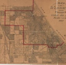
1988.144.1 A 1927 map depicting Winnetka & vicinity with Winnetka village limits noted in red. The map shows street names, subdivisions, lots, lot sizes, parks & some public buildings. The map covers the area from Lake Michigan on the east, Lake Street on the south, Sunset Ridge on the west and Jackson/Woodlawn on the north. The map was compiled by Windes & Marsh, Winnetka, Illinois. (The map is physically lapeled 1988.144.) 1988.144.2 This is similar to map 1988.144.1 and is located in Flat File Drawer 10. It is an advertising edition of 1988.144.1, published and sold for $.75 by McGuire & Orr, a North Shore Real Estate Agency with offices in Chicago and Winnetka. In addition to showing the location of the Winnetka office of McGuire & Orr, ten properties are noted in red pencil on the map and labeled A-J and nine properties are noted in green pencil and labeled 1-9. |
Creator |
Windes & Marsh |
Title |
Map of Winnetka and Vicinity |