
Archive Record
Images
Metadata
Collection |
Permanent Collection |
Catalog Number |
1991.138 |
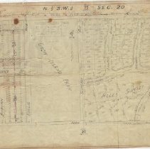
Scope & Content |
Map of area surrounding Crow Island Park, bordered by Willow Road on the north, Hibbard Road on the west, Sunset/Private Road on the south and north-south property line slightly east of Locust Road on the east. The area is offically referred to as N 1/2 S.W. 1/4 of Sec. 20. Page 24. The map shows the streets, lots, lot sizes and proposed sanitry sewer lines in the area covered, including from west to east, Vernamo Subdivision, Crow Island Park and Alles Sunset Subdivision. Written at the bottom right "Added San Dist of Chi Nov.1938" The Map is torn and taped. |
Creator |
Frank A. Windes |
Title |
Map of area surrounding Crow Island Park |