Archives
Enter a word or phrase to perform a general search across all records in the Archives catalog. You can also browse records in the catalog without performing a search.
Search Tips
- Searches are not case sensitive.
- Searching for multiple words connects them with OR by default. Matching records can contain any of the words.
- Connect multiple words with AND if you only want to see records containing both words.
- Use quotation marks to search for a phrase.
- Place an asterisk (*) at the end of a word as a wildcard.
240 results found. Records searched: 240
-
1980.101
Map w/Winnetka colored in yellow, names of streets & acreage are given
Record Type: Archive

-
-
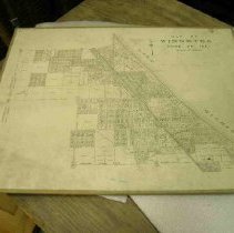
1989.285
Map by Walter Browne and Frank Windes showing real estate lots in Winnetka. Winnetka, 1907
Record Type: Archive
-
1989.3081.2
Map marked with areas not previously occupied and areas broken up from former estates. With Public Works photographs.
Record Type: Archive
-
1995.12.1-.2
copy of rendering/map showing water works and electric light plant for Village of Winnetka (2 identical copies.) also showing elevations of the Water Tower. pencil comments on back :"Proposed" "Built with straight stairs and building turned
Record Type: Archive
-
1996.114
Map Technical Drawing of proposed drainage & irrigation in Winnetka Playfield
Record Type: Archive
-
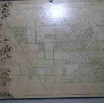
1996.85
Map: white w/colored city areas of Winnetka includes street names, numbers & acreage. Surrounding areas as well
Record Type: Archive
-
1996.86
Map: white paper blue ink with street name, number & acreage of Winnetka
Record Type: Archive
-
1996.87
Map: Dark green water color like background, yellow boundries, includes surrounding cities, street names, numbers of Winnetka
Record Type: Archive
-
1996.88
MAP: White paper, blue ink borders, includes surrounding cities street names, numbers & acreage of Winnetka.
Record Type: Archive
-
1996.89
MAP: heavy brown paper bound edges, colored lake & forest areas. Site of Lady Elgin marked. crayon markings. Penciled in info., acreage & land owner markings of Winnetka
Record Type: Archive
-
1996.96a-c
3 page set of Historical Winnetka a.) Blue print b.) Mirror image c.) copy of ( a ) Map depicts late 1880"s
Record Type: Archive
-
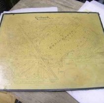
1996.98
MAP: Blue print depicting the village at about 1860, includes street names, homes & murder sites in Winnetka
Record Type: Archive
-
2000.69.24
Paper w/blue & red lettering. Map of Winnetka although street names not all accurate
Record Type: Archive
-
2000.89.1
Framed color illustrated historical map of America called "America: Its History." Used at Crow Island School
Record Type: Archive
-

-
2000.94.1
Colored map of Winnetka originally drawn by Ida Randall & Frank Windes in 1926. Additional data added 1930, 1941, 1943
Record Type: Archive
-
2000.94.1A
Colored map of Winnetka originally drawn by Ida Randall & Frank Windes in 1926. Additional data added 1930, 1941,1943
Record Type: Archive
-
2000.95.1
Negative image map. Historical map for Winnetka. Blue background w/ white lettering. Drawings around the perimeter.
Record Type: Archive
-
-
-
-
2060.9
MAP: NorthShore Drainage Map, including population of cities, water intake, sewer outlets & elevations, Railroads marked & profile shown of county line
Record Type: Archive
-
-
-
-
-
-
FIC2016.30
Development map for "White Oaks Subdivision." Map from Windes and Marsh surveyors in Winnetka. Head listed as H.H. Brown, on behalf of Murray and Terry in Chicago. Map shows plot between Willow and Sunset.
Record Type: Archive
-
FIC2016.31
"Daughaday Acres Development Study for the Division of Lots A, G, 3, 6, 7, 151 78, 82." Development south of Sunset Lane, north of Winnetka Ave.
Record Type: Archive
-
FIC2016.32
Development plan for Daughaday Acres from Windes and Marsh surveyors. North of Winnetka Ave, south of Sunset Road. Approved by Winnetka Board of Trustees and signed by Daughaday brothers.
Record Type: Archive
-
FIC2016.34
Map of the North Shore, featuring color specific boundaries for Glencoe, Winnetka, Kenilworth, and Wilmette. Map by Windes and Marsh. Paper clip with note states map title. Schools in Winnetka and Glencoe are pointed out.
Record Type: Archive
-
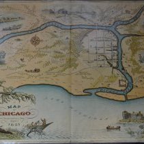
Burnham Family Collection - 2005.26.769
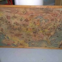
Colored, illustrated map of Chicago. Reproduction from 1933 of an historic map of Chicago about 1833. Belonged to Anita Willets Burnham. The map shows the town, then with a population of 350, located at the junction of the branches of the Chicago River. Includes street layout, historic buildings and the location of roads and trails going out from the town. Some historical information is provided, along with drawings of various buildings.
Record Type: Archive
-
Permanent Collection - 0013
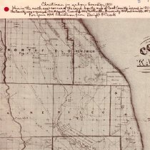
A reprinted map of the North Shore area of Cook County in 1851 that was sent as a Christmas greeting by Dwight F. Clark in 1939. Map shows Northfield, New Trier, Niles, Ridgeville, Jefferson, North Chicago Townships, and the very north part of the City. The population of each of the townships is given, and the location of roads, Indian boundry lines, rivers, and public buildings as well as homestead owners are noted. The following is written a...
Record Type: Archive
-
Permanent Collection - 0015.01
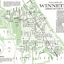
Pamphlet featuring a map of the Village of Winnetka circa 1966, Distributed free as a promotional piece by The Winnetka Bank, which was located at the Northwest corner of Elm Street and Green Bay Road. Intended audience were "newcomers" to Winnetka for their banking needs. Pamphlet features a green and white map with black text showing Winnetka streets from the Lake to the Village boundaries in the 1960s. Includes a list of street names and num...
Record Type: Archive
-
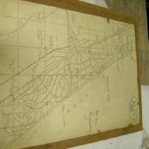
Permanent Collection - 0021
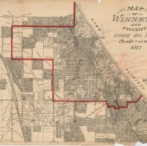
Area covered by the map extends from Jackson Ave, Glencoe on the north, Lake Michigan on the east, Lake Street, Wilmette on the south and Sunset Ridge Road on the west. The Village of Winnetka is outlined in red. Historical annotations, penciled in red, added on June 7, 1929 by Frank A Windes about Greenbay Trail and other early history of Winnetka. The same map is at 0021.02 and 1978.04
Record Type: Archive
-
Permanent Collection - 0085
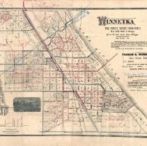
Map of "Winnetka: The North Shore Highlands, First Bluffs North of Chicago, 40 to 80 feet above Lake Michigan", insribed "Thomas G. Windes & Co., Real Estate Brokers." The map is covered in handwritten red and blue annotations carving Winnetka into 10 districts. The map includes an inset illustration of the "Winnetka Bluffs" and an inset of the elevation of the Chicago and North-Western Railway between Chicago and Winnetka.
Record Type: Archive
-
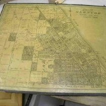
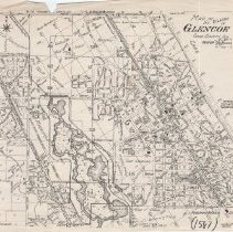
Permanent Collection - 1587
Photocopy of a map of the Village of Glencoe from an unspecified date. The map includes street names, street number grid, lot numbers, subdivisions and buildings of note, including the Public Library, Village Hall, and the Skokie Country Club's club house. The forest preserve and and the Skokie Lagoons are also covered as well as portions of Northbrook.
Record Type: Archive
-
Permanent Collection - 1975.157.a-b
Map photo copy of .a) Survey of fractional township 42 range 13 east of the 3rd principal meridian .b) township 42 North of baseline range 12 East of the 3rd principal meridian
Record Type: Archive
-
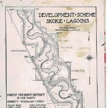
Permanent Collection - 1976.59.10
Map of the Development Scheme of the the Skokie Lagoons from Dundee Road South to Willow Road, showing Northbrook, Glencoe, Winnetka, and Northfield, the locations of dams, dikes, flood plains, CCC camp and the east and west diversion ditches, as well as a list of people from the Forest Preseve District of Cook County Board and the General Supt. On back in pencil: "Skokie Lagoons Original Plan 9" deep 1 col LTN" "b/b" or 9/9" and "OFFSET" in red ...
Record Type: Archive