Archives
Enter a word or phrase to perform a general search across all records in the Archives catalog. You can also browse records in the catalog without performing a search.
Search Tips
- Searches are not case sensitive.
- Searching for multiple words connects them with OR by default. Matching records can contain any of the words.
- Connect multiple words with AND if you only want to see records containing both words.
- Use quotation marks to search for a phrase.
- Place an asterisk (*) at the end of a word as a wildcard.
240 results found. Records searched: 240
-
Permanent Collection - 1991.136
Very incomplete and inaccurate, stylized, promotional "map" showing buildings and logos of businesses "that paid the maker" located in Winnetka's Hubbard Woods, Central and Indian Hill business districts.
Record Type: Archive

-
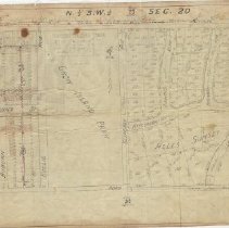
Permanent Collection - 1991.138
Map of area surrounding Crow Island Park, bordered by Willow Road on the north, Hibbard Road on the west, Sunset/Private Road on the south and north-south property line slightly east of Locust Road on the east. The area is offically referred to as N 1/2 S.W. 1/4 of Sec. 20. Page 24. The map shows the streets, lots, lot sizes and proposed sanitry sewer lines in the area covered, including from west to east, Vernamo Subdivision, Crow Island Par...
Record Type: Archive
-
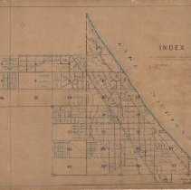
Permanent Collection - 1991.139
Index map of Winnetka, divided into 32 sections, showing locations of fire hydrants, along with subdivisions, roads, etc., taken from Winnetka Water Atlas, February 25, 1920. The map shows whether each hydrant is a Crane, Eddy or Ludlow hydrant. A notation at the bottom right states that the map is superseded.
Record Type: Archive
-
Permanent Collection - 1991.149
National Geographic Society map of the Western Theatre of World War I. A. H. Bumstead, cartographer. Black ink on white paper with blue for rivers and bodies of water. Shows railroads and tram lines as well as cities, towns and villages located within the theatre. An inset shows the location of the war zone in the context of an entire map of France and Belgium.
Record Type: Archive

-
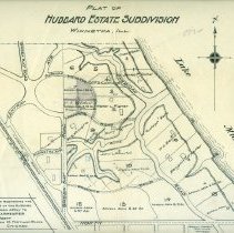
Permanent Collection - 1991.176
Plat of Hubbard Estate Subdivision showing properties in the Crescent/Fisher Road area prior to those names being given. Notes the property owners names and available lots. "For information regarding the unsold portions of the Hubbard Estate Subdivision apply to George A. Carpenter Sole Agent, Room 28 Portland Block Chicago." Map by Greeley - Howard Co. Surveyors, Chicago. On the back is a pencil diagram of one of the unsold lots with dimension...
Record Type: Archive
-
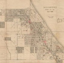
Permanent Collection - 1991.177
Map of Winnetka and vicinity showing streets, subdivisions, lots, and lot sizes. The map covers the area from Lake Michigan on the east, the New Trier Township border on the west, Jackson Street (Glencoe) on the north and Winnetka Avenue on the south. Certain lots are colored in red. The following is written on the map: "Showing location of vacant lots having accumulations of rubbish on April 18, 1918." The map is from personal papers of Will...
Record Type: Archive
-
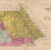
Permanent Collection - 1992.150
Map of Winnetka showing locations of sites described by Frank A. WINDES in his program "Tally-Ho Ride Around Winnetka." 19 locations shown, plus the site of the Lady Elgin sinking in 1860. The map covers the area from Lake Michigan on the east, Lake Street (Wilmette) on the south, Sunset Ridge Road on the west and Jacson/Woodlawn on the North (Glencoe). The area of Winnetka is colored yellow. The map shows subdivisions, streets, lots, parks, ...
Record Type: Archive
-
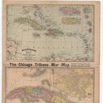
Permanent Collection - 1992.200
"Tribune War Map"- including at 1992.200.1: (1) Map of the West Indies with insets of Jamaica, Puerto Rico and four islands of the Lesser Antilles and (2) Map of Cuba with inset of Havana Harbor, and on the reverse side at 1992.200.2: (3) Map of the World.
Record Type: Archive
-
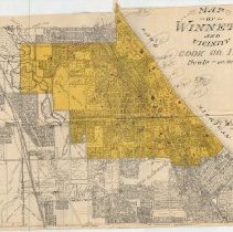
Permanent Collection - 1992.218
Map of Winnetka and vicinity with color coding: Winnnetka in yellow; the portion of Northfield in New Trier Twp in blue; and the unincorporated area in New Trier Township in pink. The map shows subdivisions, streets and house numbering system.
Record Type: Archive
-
Permanent Collection - 1992.59.01-.03
Three transparancy maps showing New Trier and Northfield Townships. The Map c (.03), the bottom map, shows streets in Wilmette, Winnetka, Glencoe and Northfield, as well as school building locations. The map shows only major roads in the western part of the townships along with school building locations. Overlaying Map c are Maps a and b. Map a (.01), the top map, shows the boundaries of the various school districts in the townships. Map b (....
Record Type: Archive
-
Permanent Collection - 1992.86
Map of the Chicago North Shore area covering the area from Lake Michigan on the east, Central Street, Evanston on the south, Pfingsten on the west and County Line Road on the north. It was drawn by Ida S. Randall and copyrighted by Windes and Marsh. Shows streets, railroads, rivers, golf clubs, airports, etc. It has attached a card advertising "Westmoor Acres," McGuire & Orr Inc. as well as a letter to J. Fred McGuire, dated November 11, 1938 a...
Record Type: Archive
-
Permanent Collection - 1994.113.2
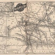
Map cut from larger pamphlet with complete map of Chicago & NorthWester Railway routes throughout Midwest. Taped together. In addition to the main map of the Chicago and NorthWestern System on the front side is an inset of the Chicago and North Western System and Connecting Lines throughout northern United States from Wisconsin west. The main map shows the location of double tracks and automatic trin control tracks. On the back side is a map o...
Record Type: Archive
-
Permanent Collection - 1994.87
Winnetka Atlas - maps by Windes and Marsh, marked with subdivision names, block and lot numbers
Record Type: Archive
-
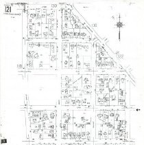
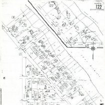
Permanent Collection - 1994.89
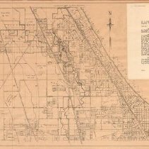
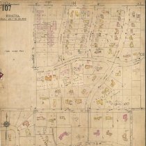
Binder of Sanborn insurance maps of Winnetka (pages 107-134), plus two unnumbered pages of more recently added subdivisions in west Winnetka, published in March 1938 with updates made into 1959. The binder had been the property of the Village of Winnetka Public Works Department. The maps show subdivisions, streets, lots, footprint of every structure, etc. with periodic updates made into 1959. The pages are bound into a hard cover binder. A rep...
Record Type: Archive
-
Permanent Collection - 1994.90
Atlas of maps of Winnetka, with locations of sewers drawn in. Accurate to 1940
Record Type: Archive
-
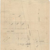
Permanent Collection - 1995.112.01
Map of Church/Hill Roads area, Winnetka, Illinois, where Church Road is intersected by Hill Road & Hill Terrace. Hand drawn in pencil by Frank R. Long. Shows lots, lot sizes and sales prices of unimproved lots in the area, as well as the footprint of the house on one improved lot.
Record Type: Archive
-
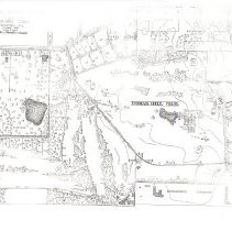
Permanent Collection - 1995.112.02
Photocopy of a map of Indian Hill Club, showing location of the golf course, club house, tennis courts and other club facilities, as well as lots laid out around portions of the club grounds. The location of the Kenilworth Sanitorium is noted in the lower right of the map.
Record Type: Archive
-
Permanent Collection - 1996.103
Map of Winnetka & vicinity. Winnetka area colored yellow, includes street names.
Record Type: Archive
-
Permanent Collection - 1996.104
Modern map of Winnetka includes streets, schools churchs & parks. Black ink lines Blueprint look
Record Type: Archive
-
Permanent Collection - 1996.105
Topographical survey map of N W Winnetka Black ink drawings
Record Type: Archive
-
Permanent Collection - 1996.106
North Shore Map of glencoe, Winnetka , Kenilworth, Northbrook, Northfield & Glenview. Boundries in crayon includes street names
Record Type: Archive
-
Permanent Collection - 1996.107
Color map of Chicago including Historic Sites & Points of interest from exposition
Record Type: Archive
-
Permanent Collection - 1996.108
Early Winnetka map with the name & location of early settlers property hand drawn black ink
Record Type: Archive
-
Permanent Collection - 1996.109
Map of Winnetka including street names. Black ink drawing.
Record Type: Archive
-
Permanent Collection - 1996.113
The official village of Winnetka zoning map on Large white paper. Blue printing drawing of Winnetka including street names
Record Type: Archive
-
-
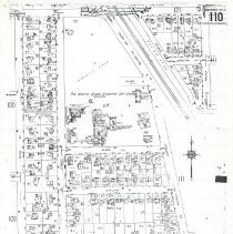
Permanent Collection - 1996.120.2
Photocopy of updated map of Winnetka from Cook County No. Shore index, Page 110. Map shows streets, subdivisions, lots and location of structures thereon. Portion of Winnetka shown: Willow Road on the north, Walnut/Church Streets on the east, corporate limits extending from Winnetka Avenue to Golf Lane on the south, and Golf Lane/Ridge Avenue on the west. See 1996.120.6 for Key Map "N" of Winnetka, Illinois showing this and other detail sheet...
Record Type: Archive
-
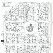
Permanent Collection - 1996.120.3
Photocopy of updated map of Winnetka from Cook County, No. Shore index, Page 111. Map shows streets, subdivisions, lots and location of structures thereon. Portion of Winnetka shown: Essex Road/Sheridan Road on the east, Sunset Road on the south, Walnut St./Church Road on the west and Willow Road on the north. ...
Record Type: Archive
-
Permanent Collection - 1996.120.4
Photocopy of updated map of Winnetka from Cook County No. Shore index, Page 121. Map shows streets, subdivisions, lots and location of structures thereon. Portion of Winnetka shown: Pine Street on the north, Sheridan Road on the northeast, Poplar on the east, Willow Road on the south and Wilson/Maple on the west. ...
Record Type: Archive
-
Permanent Collection - 1996.120.5
Photocopy of updated map of Winnetka from Cook County North Shore index, Page 122. Map shows streets, lots, subdivisions and loction of structures on lots. Portion of Winnetka shown on the map: Poplar Street on the west, Sheridan Road on the northwest, Spruce on the north, Lake Michigan on the east and Willow Road on the south. ...
Record Type: Archive
-
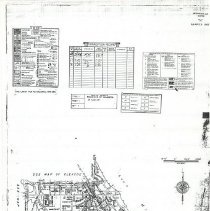
Permanent Collection - 1996.120.6
Photocopy of Winnetka Key Map "N" dividing the village into sections shown on Pages 101 - 138 of the Sanborn insurnace maps. See 1996.120.2-5 for Pages 110, 111, 121, 122, respectively. The map is dated March 1965 and has a correction record through January 1984. The map includes a Key and information on Coding of Structural Units for Fireproof and Non-combustible Buildings. This is an update of the index of the Sanborn insurance maps found a...
Record Type: Archive
-
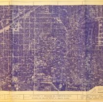
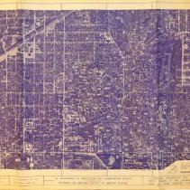
Permanent Collection - 1996.121.1
Floodplain Topographic Map North Branch of the Chicago River Lake and Cook Counties, Illinois. Sheet NB-21. Topographic lines on aerial photograph of Winnetka. Prepared by Alster and Associates, Inc. Madison, Wisconsin. Date of photography April 1972. Date of mapping Summer 1972. Prepared for U.S. Department of Agriculture Soil Conservation Service in cooperation with Metropolitan Sanitary District of Greater Chicago.
Record Type: Archive
-
Permanent Collection - 1996.121.2
Floodplain Topographic Map North Branch of the Chicago River Lake and Cook Counties, Illinois. Sheet NB-21. Topographic lines on aerial photograph of Winnetka. Prepared by Alster and Associates, Inc. Madison, Wisconsin. Date of photography April 1972. Date of mapping Summer 1972. Prepared for U.S. Department of Agriculture Soil Conservation Service in cooperation with Metropolitan Sanitary District of Greater Chicago. Copy of 1996.121.1.
Record Type: Archive
-
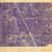
Permanent Collection - 1996.121.3
Floodplain Topographic Map North Branch of the Chicago River Lake and Cook Counties, Illinois. Sheet NB-6. Topographic lines on aerial photograph of Winnetka. Prepared by Alster and Associates, Inc. Madison, Wisconsin. Date of photography April 1972. Date of mapping Summer 1972. Prepared for U.S. Department of Agriculture Soil Conservation Service in cooperation with Metropolitan Sanitary District of Greater Chicago.
Record Type: Archive
-
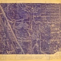
Permanent Collection - 1996.121.4
Floodplain Topographic Map North Branch of the Chicago River Lake and Cook Counties, Illinois. Sheet NB-7. Topographic lines on aerial photograph of Winnetka. Prepared by Alster and Associates, Inc. Madison, Wisconsin. Date of photography April 1972. Date of mapping Summer 1972. Prepared for U.S. Department of Agriculture Soil Conservation Service in cooperation with Metropolitan Sanitary District of Greater Chicago.
Record Type: Archive
-
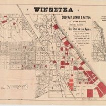
Permanent Collection - 1996.128
Winnetka map of plots of land for sale on the North Shore from Kenilworth to North Avenue (renamed Tower Road). The map includes streets and subdivsions. Red lots on the map are those for sale by Galloway, Lyman & Patton, 1213 Tacoma Building, Chicago. Included is a sectional map from Chicago Harbor to Winnetka and an elevation scale of the C & NW RR from Chicago to Winnetka.
Record Type: Archive
-
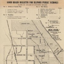
Permanent Collection - 1996.129
Map of Good Roads Bulletin for Illinois Pubic Schools, includes basics of judging roads and the number of points awarded for each condition category. The map covers the Villages of Winnetka, Kenilworth, Wilmette and Gross Point, with additional areas west to the New Trier Township line included.
Record Type: Archive
-
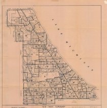
Permanent Collection - 1996.72
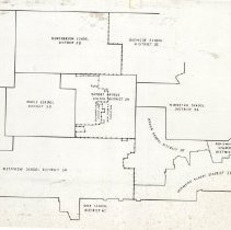
Map of New Trier Township revised March 1, 1981 as published by Stanley T. Kusper, Jr., Cook County Clerk. The map is divided into 81 districts of unspecified purpose and includes streets and locations of schools, parks, country clubs, etc.
Record Type: Archive
-
Permanent Collection - 1996.97
Frank A. Windes Historical Map of Winnetka, drawn and delineated by Ida S. Randall, April 3, 1934. Ink on architectural drafting film. Original. Black and white line version of 1989.2037.
Record Type: Archive
-
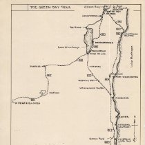
Permanent Collection - 1997.1
Map of the Green Bay Trail from Chicago, Illinois to Green Bay, Wisconsin, with alternative routes noted -- by Charles C. Henderson for the Wilmette Historical Commission.
Record Type: Archive