
Archives
Enter a word or phrase to perform a general search across all records in the Archives catalog. You can also browse records in the catalog without performing a search.
Search Tips
- Searches are not case sensitive.
- Searching for multiple words connects them with OR by default. Matching records can contain any of the words.
- Connect multiple words with AND if you only want to see records containing both words.
- Use quotation marks to search for a phrase.
- Place an asterisk (*) at the end of a word as a wildcard.
240 results found. Records searched: 240
-
Permanent Collection - 3116
A plat of survey for a John Dale Subdivision. The land is in the northeast 1/4 of the southeast 1/4 of Section 20; an area bound by Willow St, Hazel St, Mount Pleasant Ave, and Linden St. This plat is for the same area as a previous 1872 plat (see Object ID 3117) but in this plat, a private alley is shown running between lots 5 and 6 off Hazel Street). The document is signed by several individuals, including the Justice of the Peace, president of...
Record Type: Archive

-
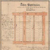
Permanent Collection - 3117
Plat of survey for John Dale's first Winnetka subdivision. The land is in the northeast 1/4 of the northeast 1/4 of the southeast 1/4 of Section 20, T 42, R 13; an area bound by Willow St, Hazel St, Mount Pleasant Ave, and Linden St. The subdivision has been divided into 36 lots; dimensions are given. The document is signed on behalf of the county surveyor by the deputy surveyor, the justice of the peace, and Winnetka village clerk. On the rev...
Record Type: Archive
-
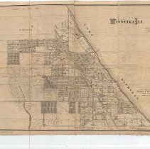
Permanent Collection - 3118
Map of Winnetka showing streets and numbered lots. The map includes a blow-up of a small section of Sheridan Rd lots along the lake. In red pencil, the address of Murray and Terry's Dearborn St. office has been corrected. In various places, names and addresses have been written on the map in pencil. Copywrited 1910.
Record Type: Archive

-
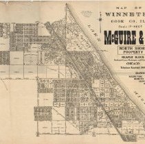
Permanent Collection - 3119
Map distributed by "McGuire and Orr: North Shore Property." The map itself was created by Windes and Marsh, whose names appear to the left of the title and in the lower right with a copyright date of 1911. The detailed map provides street names, lot numbers and sizes.
Record Type: Archive
-
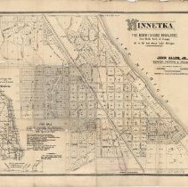
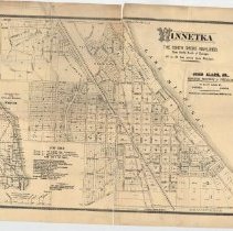
Permanent Collection - 3120
3120.01: Map of "Winnetka, The North Shore Highlands," showing plots for sale by John Alles, Jr. in Alles' 1st Addition, Dale's 3rd Addition and Sherlock's Subdivision. Includes sales information. The map being used is copyright by B. F. Culver 1890, Chicago and shows Winnetka from Lake MIchigan on the east to Beech Street on the west, Lakeview/North Aves. on the north to Winnetka Ave. on the south. An inset shows a map of Chicago north to Win...
Record Type: Archive
-
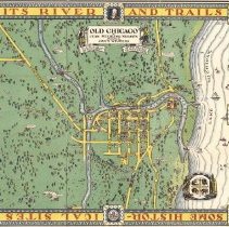
Permanent Collection - 3272
Illustrated map of Chicago. "Rivers and Trails of Old Chicago" by Jean Sterling Nelson and drawing by John Winters. Copyright 1940, Jean Sterling Nelson. *Unfolded in South Room, moving to flat files - 1/13/2015 - SHE
Record Type: Archive
-
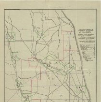
Permanent Collection - 3306.1
Maps: Indian Trails & Villages centered to the North Branch of the Chicago River from 1804 as shown by weapons and implements of the Stone Age. Penciled in is the site of the Barry Point Tavern. See 1988.371 for a similar map. (See 2288.1)
Record Type: Archive
-
Permanent Collection - 3306.2
Map by Albert F. Scharf showing "Indian Trails and Villages" in 1804 as shown by weapons and implements of the stone age. One of four copies. The other three are ID 3306.3, ID 3306.4 and ID 1988.371 Accompaning this map and Maps 3306.3 and 3306.4 is a letter (ID 3306.5) dated November 10, 1905 from Albert F. Scharf to Frank A. Windes referencing, among other things unrelated to Winnetka, the site of the Patterson Tavern and an abandoned road.
Record Type: Archive
-
Permanent Collection - 3306.3
Map by Albert F. Scharf showing "Indian Trails and Villages" in 1804 as shown by weapons and implements of the stone age. One of four copies. See also ID 3306.2 and 3306.4 and ID 1988.371.
Record Type: Archive
-
Permanent Collection - 3306.4
Map by Albert F. Scharf showing "Indian Trails and Villages" in 1804 as shown by weapons and implements of the stone age. One of four copies. (See also ID 3306.2 and 3306.3 and ID 1988.371.) This copy has been produced by the Chicago Historical Society in January 1912.
Record Type: Archive
-
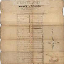
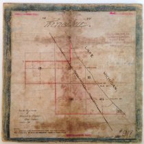
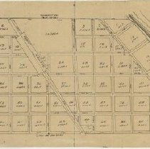
Permanent Collection - 3315
Groveland subdivision addition to Winnetka from 1874. It consists of the area bounded by Pine, Locust, Willow and Beech Streets, with Central Street running down the middle. The area has been divided into 12 blocks, with blocks 1-10 located in the area north of Ash Street divided into 20 lots each. Diminsions of lots are given. Blocks 11-12 located between Ash and Willow have not been subdivided. Signed by the Winnetka Village Trustees, the ...
Record Type: Archive
-
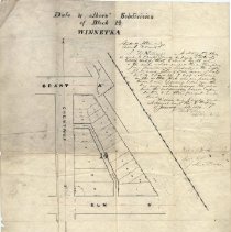
Permanent Collection - 3326
Plat of John T. Dale and others' subdivisions of block 14 in Winnetka, which includes R.R. Avenue (Green Bay Road), Grant Av (Spruce Street), Chestnut Street, and Elm Street. The parcel is divided into 19 lots. Dimensions are given. Surveyed December 8, 1885, by John B. Westerfield. The plat is signed by the clerk of the Winnetka Village Council and notarized by Max K. Meyer January 8, 1886. On the reverse side, the plat is signed by the Coo...
Record Type: Archive
-
Permanent Collection - 3332.1
Hand-drawn map of Winnetka, mounted on a cardboard square. In the bottom left appears "From the files and records of Windes and Marsh, Village Engineers, January 1931." They note that the map itself was drawn about 1890.
Record Type: Archive
-
Permanent Collection - 3332.2
A map compiled by Windes and Marsh, which depicts Winnetka highlighted in yellow, and the commuities that surround it.
Record Type: Archive
-
Permanent Collection - 3332.3
A map of Winnetka copyright by B. F. Culver 1890, Chicago. It has been appropriated by John Alles Jr. for listing real estate. The map is identical to 0085, except for the name under the title, and in this version, the illustration of the bluffs has been replaced with an advertisement of for-sale properties in Alles' 1st Addition, Dale's 3rd Addition, and Sherlock's Subdivision. There is an inset of a sectional map from Chicago Harbor to Winnet...
Record Type: Archive
-
Permanent Collection - 3350
Certificate of membership to the Winnetka Historical Society, drawn by Peter Gerhard in 1938, featuring an historical map of Winnetka. The legend and map identify the location of 42 sites around the Village. Five copies are original version (1938). One copy is signed by former WHS Board President Eugene Rummler. A green and white enlarged and revised map (larger: 14.5 in. x 9.5 in. high) from the 1963 features the WHS "Indian head" logo and spa...
Record Type: Archive

-
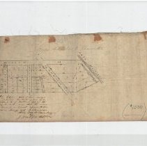
Permanent Collection - 3424.1
Plat of John T. Dale's Addition to Winnetka as certified by Alex Walcott, County Surveyor June 27, 1871. Shows area bounded on N. by Willow, W. by Fairview, E. by Lake Michigan, including Willow, Fairview, Woodland, Lake and First Avenue/Streets. Four subdivisions are shown with lots and dimensions therein. Certificates of the County Surveyor, Winnetka Village Council, a Justice of the Peace and Cook County Recorder are written on the Platt
Record Type: Archive
-
Permanent Collection - 3424.2
Plat of John T. Dale's Addition to Winnetka as certified by Alex Walcott, County Surveyor June 27, 1871. Shows area bounded on N. by Willow, W. by Fairview, E. by Lake Michigan, including Willow, Fairview, Woodland, Lake and First Avenue/Streets. Four subdivisions are shown with lots and dimensions therein. Certificates of the County Surveyor, Winnetka Village Council, a Justice of the Peace and Cook County Recorder are written on the Platt.
Record Type: Archive

-
Permanent Collection - 3482
Map, copy of plan of Winnetka (as subdivided into 71 lots) as surveyed by John Van Horn in 1855, subdivided by Charles E. Peck on March 1, 1858. This map copied from the re-record of same filed in County Recorder's Office, Book 5, Page 78, Doc. 119381, August 8, 1873. Refer also to #1988.370.1
Record Type: Archive
-
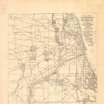
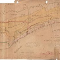
Permanent Collection - 3517
Map from 1910 showing water sheds west of North Shore suburbs with sites of septic tanks, sewer outlets & water intake. Water shed area colored yellow. Several areas are outlined in red or green. The map area covered extends from Chicago on the south to Waukegan on the north, Lake Michigan on the east to the DesPlaines River on the west. An inset shows elevation profile along the Lake/Cook County line from Lake Michigan to the DesPlaines River. A...
Record Type: Archive
-
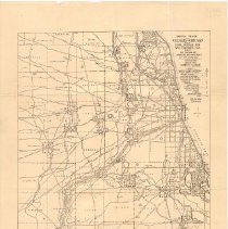
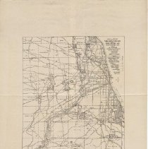
Permanent Collection - 3520
Map of the North part of Cook County East of the Des Plaines River showing proposed and existing sewer outlets, including those in Winnetka and Glencoe. Portions of the map are hand colored. The map extends from the Ravenswood section of Chicago on the South to the Lake County line on the North and from the Des Plaines River on the west to Lake Michigan on the East.
Record Type: Archive
-
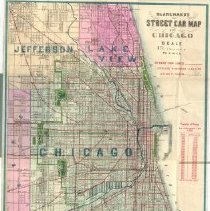
Permanent Collection - 3617
1873 Street Car map of Chicago showing streeet car routes and city and suburban lines on steam railroads. The area covered extends from Wilson Avenue on the north, Lake Michigan on the east, 67th Street on the south and Central Avenue on the west. Distributed by a real estate company: Belden F. Culver, 85 Washington Street, Chicago. The map lists Chicago population from 1837-1887.
Record Type: Archive
-
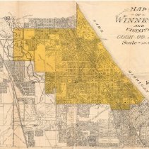
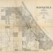
Permanent Collection - 3886.01
Map of "Winnetka and Vicinity". The map covers the area from Jackson/Woodlawn Streets on the north, Lake Michigan on the east, Avoca/Washington/southern Kenilworth Village limit on the south and the New Trier Township border on the west. The map shows street, lots, lot sizes, parks, schools and subdivisions and is color coded to indicate zoining: uncolored - Class "A" residence; yellow - Class "B" residence; green - Class "C" commercial, and r...
Record Type: Archive
-
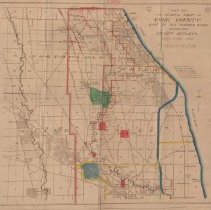
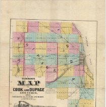
Permanent Collection - 4078
Map of Cook & DuPage Counties in 1868. Shows Railroads, Post Roads, Chicago, Villages, Townships & Boundries. Townships are colored blue, pink, green, yellow or white.
Record Type: Archive
-
Permanent Collection - 4131
Map of Winnetka, including street names, acreage, subdivision sites and lot numbers. The map is mounted on cloth. There are a few handwritten notes on it giving acerage of some locations and price per acre. The maps states that it was compiled from records and surveys by Frank A. Windes, former Village Engineer of Winnetka and was drawn by C. O. Axell. The map is stamped with the name of "Everett W. Osgood, Insurance, 622-159 LaSalle Street, C...
Record Type: Archive
-
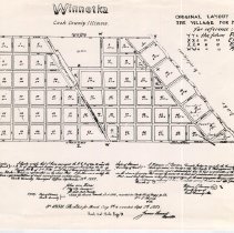
Permanent Collection - FIC2016.04.01
Photocopy of a map, possibly a hand-drawn map, of Winnetka as originally subdivided into 71 blocks and streets by the Cook County surveyor in 1855. In upper right, text reads, "ORIGINAL LAYOUT OF/ THE VILLAGE FOR MR. PECK..." The area covered extends from Lake MIchigan on the east, Willow Road on the south, Pine Street on the north and an unidentified street on the west. In the lower part of the map are the certifications of the County Surveyo...
Record Type: Archive
-
Permanent Collection - FIC2016.04.02
Map, possibly a copy of a hand-drawn map, of Winnetka. At top, text reads, "EARLY WINNETKA." At right center, text reads, "OLD SETTLERS' PROPERTY" and includes several names (including Simon Doyle, Erastus Patterson, and Aex. McDaniel) with a key to property location and years of settlement. At bottom: " DRAWN BY DAVID W. JAMES, JR./ 1952."
Record Type: Archive

-
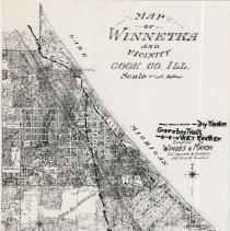
Permanent Collection - FIC2016.04.03a
Photograph of a map of Winnetka with handwritten notes. The map shows the location of the Green Bay Trail in Winnetka both during dry weather and wet weather. At top, text reads, "MAP/ OF/ WINNETKA/ AND/ VICINITY/ COOK CO. ILL./ Scale IN FEET..." Above the text, "Compiled by/ WINDES & MARSH," is a key in handwritten black ink that reads, "Dry Weather./ Greenbay Trails/ WET Weather." Trails are marked along the map in the same black ink.
Record Type: Archive
-
Permanent Collection - FIC2016.04.06
Map of Winnetka issued in 1890 by Belden F. Culver Real Estate Agency. The real estate map has black ink on off-white paper and depicts Winnetka with numbered blocks, subdivisions, street names, lots and lot sizes. Handwritten pencil notes appear in several places. At right center, text reads, "THIS MAP ISSUED BY/ BELDEN F. CULVER, 59 DEARBORN ST.,/ CHICAGO, ILLINOIS/ REAL ESTATE AGENCY." An inset showing the elevation between Chicago and Winne...
Record Type: Archive

-
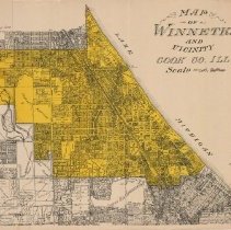
Permanent Collection - FIC2016.16
Map of Winnetka and vicinity; Winnetka is highlighted in yellow. Parts of Glencoe, Northfield, Kenitworth and Wilmette are included on the map. The map shows subdivisions, streets, lots, lot sizes, parks and schools.
Record Type: Archive
-
Permanent Collection - FIC2016.161.01
HIstoric Taylorsport map drawn by Frank A. Windes - "Custodian of the Winnetka Historical Society." The map includes sketches of buidlings, landscapes, etc. drawn by Anita Willets Burnham. The map covers the area from Lake Michigan on the east, Westmoor on the south, New Trier Township boundary on the west and South Avenue (Glencoe) on the north, and includes streets and some buildings, parks, schools, etc. A legend on the right identifies 30 ...
Record Type: Archive
-
Permanent Collection - FIC2016.161.02
This is a second copy of the map located at FIC2016.161.01
Record Type: Archive
-
Permanent Collection - FIC2016.18
Photocopy of a map, circa 1907, of Winnetka and southern Glencoe, covering the area from Lake MIchigan on the east, Winnetka Avenue on the south, Valley on the west and Jefferson on the north. Shows subdivisions, streets, parks, schools. The date "c 1907" is penciled in in the lower right.
Record Type: Archive
-
Permanent Collection - FIC2016.19
This is a second photocopy of a map of Winnetka and southern Glencoe; the first photocopy is found at FIC2016.18. See FIC2016.18 for information.
Record Type: Archive
-
Permanent Collection - FIC2016.21
A study for the development plan for "Daughaday Acres" by offices of C. Colton Daughaday, 230 N. MIchigan Ave., Chicago. The map shows lots bordering DeWindt Road from Winnetka Avenue on the south to Sunset Lane on the north. Some lots are shaded pale green with some of these outlined in blue pencil with lot sizes given. The writing on the map is faded.
Record Type: Archive
-
Permanent Collection - FIC2016.24
Village of Winnetka zoning use district map dated January 1, 1976. Significant tear in map. Map shows the location and boundaries of the use district provided by Village zoing ordinance as amended through and including February 26, 1968. The is the same map as is located at 2007.21.02
Record Type: Archive

-
Permanent Collection - FIC2016.29
Winnetka Historical Society map of Winnetka drawn by Frank A. Windes and Peter Gerhard in December 1938. Map used as commemorative gift for the Society, with penciled note on this copy for 500 copies to be produced at smaller size. Space on the map top to denote specific member of society. A legend on the right provides the key to 43 points of interest around the Village.
Record Type: Archive
-
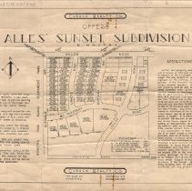
Permanent Collection - FIC2016.33
Promotional map of Alles' Sunset Subdivision off of Willow Road, as offered by Cusack Realty Co. Dimensions written in pencil along the top of the map: 108 x 176 x 168 x 108. The area covered by the map covers Locust Road on the east, Sunset Road on the south, Glendate Ave. on the west and Willow Road on the north, with Mt Pleasant Road, Linwood Road and Rosewood running through the subdivision. 47 lots are shown on the map as being "for sale" w...
Record Type: Archive
-
Permanent Collection - FIC2016.78
"Village of Winnetka, Cook Co., IL, District Map" showing use districts in the Village provided by the ordinance adopted and approved on January 17, 1922 as amended to and including April 21, 1959, The map was created May 15, 1959. Map is shaded to show residential land plots, commercial, and industrial zones. Legend in lower left. Official village seal in right center. The map shows streets as well as the location of schools, churches, and park...
Record Type: Archive

-
Permanent Collection - FIC2016.90
Map of Winnetka by Windes & Marsh, dated 1-20-1930. The map is printed with black ink on white paper. It shows subdivisions and streets, as well as the location of schools and parks. The house numbering system grid is displayed on the map.
Record Type: Archive
