Archives
Enter a word or phrase to perform a general search across all records in the Archives catalog. You can also browse records in the catalog without performing a search.
Search Tips
- Searches are not case sensitive.
- Searching for multiple words connects them with OR by default. Matching records can contain any of the words.
- Connect multiple words with AND if you only want to see records containing both words.
- Use quotation marks to search for a phrase.
- Place an asterisk (*) at the end of a word as a wildcard.
240 results found. Records searched: 240
-
Permanent Collection - 1976.59.11
Map of the Development Scheme of the the Skokie Lagoons from Dundee Road South to Glenview Road, showing Northbrook, Glencoe, Winnetka, Northfield, Wilmette, and Glenview. Similar to but more detailed than the map at 1976.59.12. Plots the locations of dams, dikes, flood plains, elevations, bridges, river beds, the river, ditches, roads, and barracks at the National Park Service E.C.W. Headquarters and U.S. Army Headquarters, as well as provides...
Record Type: Archive

-
Permanent Collection - 1976.59.12
Map of the Development Scheme of the the Skokie Lagoons from Dundee Road South to Glenview Road, showing sections of Northbrook, Glencoe, Winnetka, Northfield, Wilmette, and Glenview. Similar to but less detailed than the map at 1976.59.11. Some areas of the map colored in with a blue pencil. Plots the locations of dams, dikes, flood plains, bridges, river beds, the river, channels and diversion ditches, roads, and the Skokie Valley Park CCC C...
Record Type: Archive
-
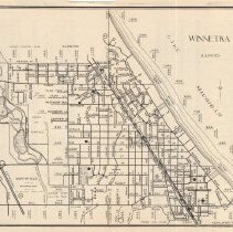
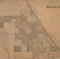
Permanent Collection - 1978.04
Map of Winnetka, Illinois and Vicinity. Winnetka is outlined in red. This is the same map that is identified as 0021 and 0021.02.
Record Type: Archive
-
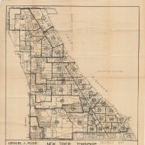
Permanent Collection - 1978.55
New Trier Township voting district map. The map is divided into the 40 local voting districts, and states that it is "correct to July 1937" and "Michael J. Flynn, County Clerk."
Record Type: Archive
-
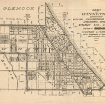
Permanent Collection - 1988.100
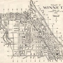
Map of Winnetka showing village boundaries, streets, subdivisions, parks, forest preserve, schools, all superimposed on the house numbering system.
Record Type: Archive
-
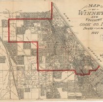
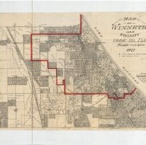
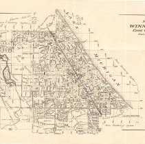
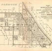
Permanent Collection - 1988.144
1988.144.1 A 1927 map depicting Winnetka & vicinity with Winnetka village limits noted in red. The map shows street names, subdivisions, lots, lot sizes, parks & some public buildings. The map covers the area from Lake Michigan on the east, Lake Street on the south, Sunset Ridge on the west and Jackson/Woodlawn on the north. The map was compiled by Windes & Marsh, Winnetka, Illinois. (The map is physically lapeled 1988.144.) 1988.144.2 ...
Record Type: Archive
-
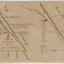
Permanent Collection - 1988.152.01-.03
Map sketches (two copies) and one negative showing a triangular section of land in northeast Winnetka bordered by Lake Michigan on the east, Tower Road on the north, and Pine Street on the south. The west boundary is undefined but would be roughly Prospect Avenue. Written on the map is "Survey and approval of school lands in Twn 42 R 13 recorded Oct. 14, 1859 B.H. of Maps page 182 as Doc. No 24743. Copy made from Win Park Dist Abstract Lake Fro...
Record Type: Archive
-
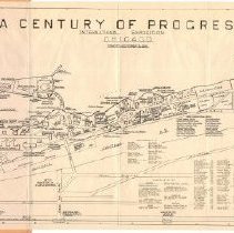
Permanent Collection - 1988.167
Map of the "Century of Progress" 1933 World Fair (May 27 - October 31, 1933). The map, with coordinates, shows the layout of the fairgrounds, including the location of buildings, surrounding streets, railroads, airstrips, streetcars, bus depots and boat landings. An alphabetically arranged legend gives the coordinate key for various sites. The map folds up into a paper cover.
Record Type: Archive
-
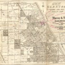
Permanent Collection - 1988.168.01
1919 map of Glencoe, Illinois prepared by Windes & Marsh for Murray & Terry, North Shore Suburban Real Estate, 40 North Dearborn Street, Chicago. The map covers the area from Lake Michigan on the east, Scott Avenue on the south, the limits of New Trier Township on the west, and Cook County line on the north. It shows streets, subdivisions, lots and lot sizes. Twelve lots north of Beach Road and east of Sheridan Road are marked in red ink and i...
Record Type: Archive
-
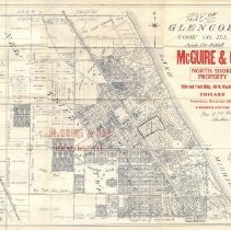
Permanent Collection - 1988.168.02
1915 Map of Glencoe, Illinois prepared by Windes & Marsh for McGuire & Orr, Real Estate, 69 W. Washington St., Chicago. The map covers the area from Lake Michigan on the east, Scott Avenue on the south, West Limits of New Trier Township on the west and the Cook County line on the north. It shows streets, subdivisions, lots and lot sizes, as well as Glencoe Village Limits and New Trier Township Limits. Written in ink on the map is "Mrs. O. M. K...
Record Type: Archive
-
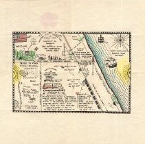
Permanent Collection - 1988.174
Comic map of Hubbard Woods area drawn by Anita Burnham and family, Christmas 1925. The map is partially colored.
Record Type: Archive
-
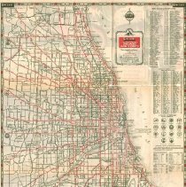
Permanent Collection - 1988.186
Road map of Chicago and vicinity prepared by Sinclair Motor Oil Company as an advertisement for the 1933 Century of Progress. Major through roads are printed in red. The map includes an index to golf and country clubs and an index of cities and towns with their populations. On the back side is a map of the Century of Progress, pictures of the fair site and the Sinclair Dinosaur Exhibit, and facts about Sinclair. A stamp on the back reads "Abe...
Record Type: Archive
-
Permanent Collection - 1988.238.01-04
1988.238.01 - Rand McNally War Map of the Italian Front 1918 - a strategic map of the battle ground in Northern Italy. Map folds into a paper cover. 1988.238.02 - Geographia Ltd. Map of French Front, northern section from St. Quentin to St. Mihiel 1988.238.03 - Daily Telegraph War Map of the New British Front (No. 13). Map folds into a paper cover. 1988.238.04 - Daily Telegraph War Map of the French Fighting Line (Verdun to Belfort)....
Record Type: Archive

-
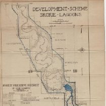
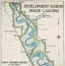
Permanent Collection - 1988.279.09
Map of the "Development Scheme Skokie Lagoons" published by the Forest Preserve District of Cook County. The map, in color, shows the Skokie Lagoons from Dundee Road on the north, Glencoe/Winnetka boundaries on the east, Willow Road on the south and Skokie Blvd. on the west. The lagoons and related flood plains are colored in blue, woodlands in green and the east and west diversion ditches in red. The location of dams, flood plains and dikes a...
Record Type: Archive
-
Permanent Collection - 1988.371
Map of Indian Trails & Villages in Chicago & Cook, DuPage & Will Counties of 1804 as shown by weapons and implements of the Stone-Age. At the bottom of the map is printed "Chicago Historical Society." The same map is at 3306.2, 3306.3 and 3306.4.
Record Type: Archive
-
Permanent Collection - 1988.372
Map of Winnetka drawn by Peter Gerhard and used as a certifiction to certify membership in the Winnetka Historical Society. The map shows village limit boundaries and streets and contains a legend showing the location of 43 points of interest around the village.
Record Type: Archive
-
Permanent Collection - 1988.373
Map of Winnetka and Vicinity Cook Co. Ill. Hand drawn numbers from 1-29 indicating "School Locations 1856 to 1949 From Winnetka Historical Society Records by Frank A. Windes - December 1949." All but two of the locations are in Winnetka. The map covers the area from Lake Michigan on the east to Sunset Ridge on the West, Jackson Ave. (Glencoe) on the north to Lake Street on the south. The area of Winnetka is colored yellow. It shows lot number...
Record Type: Archive
-
Permanent Collection - 1988.375
"Map of Lake Michigan showing the area in which the remains of the "S.S. Lady Elgin" probably could be found" handwritten on US Army Corps of Engineers survey of Lake Michigan. Noted as being No. 75. Receipt for S. S. Otis from 12-14-1960. Several markings and other written notes related to Lady Elgin search.
Record Type: Archive

-
Permanent Collection - 1988.464.1
Map of Winnetka streets superimposed on the house numbering grid. On the reverse side, there is a street guide naming Winnetka streets in alphabetical order, giving the direction each street runs, and providing the coordinates of each street on the grid.
Record Type: Archive
-
Permanent Collection - 1988.464.2
1919 map (two copies) of Winnetka showing streets, subdivisions, and the grid for house numbering system.
Record Type: Archive
-
Permanent Collection - 1988.466
A map of Winnetka and several blocks of Glencoe, including street names, subdivision names, lots and lot sizes, and the acreage of some open spaces. In pencil the street name of "Edison" has been changed to "Scott" and "Ashland" to Chesterfield."
Record Type: Archive
-
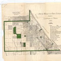
Permanent Collection - 1988.467
Map of Winnetka Park District showing village boundaries in green, streets, subdivisions and lots, as well as the location of the 21 parks, each shown in green, within the village. The map gives the acerage of each park; total acerage is 118.57 acres.
Record Type: Archive
-
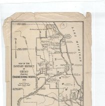
Permanent Collection - 1988.468
1928 map of the Chicago Sanitary District, showing its boundaries and the communities therein (including Winnetka), as well as the location of pumping stations, sewage treatment works, rivers, and canals.
Record Type: Archive
-
Permanent Collection - 1988.474
Map of Winnetka printed in the April 3, 1926 edition of The Winnetka Talk. Written on the map in pencil: "probably around 1875 and showing points of historic interest." The map shows some streets in Winnetka and superimposted are sites of historic homes, buildings and events. The south and west sections of the map show the owners of outlying estates and their acreage.
Record Type: Archive
-
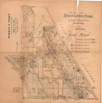
Permanent Collection - 1988.507
Undated map of Highland Park, Illinois prepared by Windes & Marsh and drawn by M. A. Stockley for Murray & Terry, 40 North Dearborn Street, Chicago. The map is labeled as a "Use Map," identifying "A" residence district, "B"residence district, local business districts, commercial distsricts and parks, golf courses, etc. In addition, it identifies streets and railroads.
Record Type: Archive
-
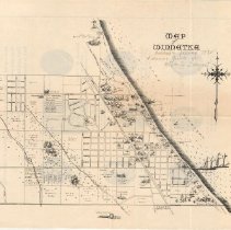
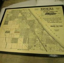
Permanent Collection - 1988.57.3
Map of Winnetka from 1907 used by Browne, Windes & Co. for real estate sales purposes. Advertizes Winnetka as "The First Choice Suburb North of Chicago, High and Healthy" with "High-class residence property, schools, churches, library, city delivery, large forest trees, sewer system, stone walks, macadamized streets and municipal ownership of water and electric light plants. No Saloons. No factories. Values and Improvements Rapidly Advancing....
Record Type: Archive
-
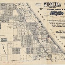
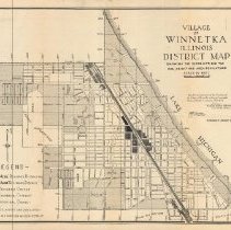
Permanent Collection - 1988.587
Street map of Village of Winnetka drawn for the Winnetka Chamber of Commerce in 1956. The map shows streets by name, the location of certain publlic buildings, and the street numbering grid for the village. There are two originals of the map (1988.587.1-2), one photocopy (1988.587.4) and one negative (1988.587.3). On the reverse side of the photocopy is a listing of streets with their directional axis as well as their location on the street nu...
Record Type: Archive
-
Permanent Collection - 1988.68.3
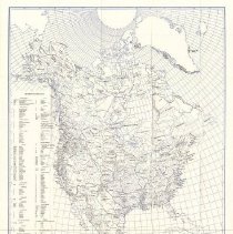
Tribal Map of North America. Identified as University of California Map Series, No. 13. Accompanies "Southwest Museum Leaflets: America's Indian Background, an introduction to the subject of Indians in the United States area" Number 18, 1945 by: Edwin F. Walker and a List of available books and leaflets from the Southwest Museum. Edwin Walker spent his childhood in Winnetka, Illinois. He credited finding Indian artifacts in Winnetka as a c...
Record Type: Archive
-
Permanent Collection - 1989.101
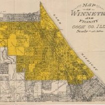
Map of Winnetka colored in yellow, showing streets, subdivisions, lots, lot sizes and parks. The map also shows the portions of Glencoe, Northfield, Kenilworth and Wilmette that surround Winnetka.
Record Type: Archive
-
Permanent Collection - 1989.2037
Historical Map of Winnetka, 1830 to 1934. Incorporated in 1869, compiled from records by Frank A. Windes, Winnetka Engineer, 1934. Map designed by Frank A. Windes, delineated by Ida S. Randall on April 3, 1934. Handcolored, framed, actual map size 32.13" x 22.15" Copyright Frank A. Windes, April 1934. Features a drawn map of Winnetka in 1934 marking important historical places with illustrations. A full-size reproduction was made and framed i...
Record Type: Archive
-
Permanent Collection - 1989.2053
Map of Winnetka prepared by Frank A. Windes for Browne, Windes, and Co.. a real estate and loan company with offices in Chicago and Winnetka, as an advertisement. The map covers the Village of Winnetka plus parts of Glencoe and Northfield, from Jefferson Ave in Glencoe on the north, Lake Michigan on the east, Winnetka Ave on the south and Valley on the west. It shows streets, subdivisions and lots, with some dimensions. The portion of the Winn...
Record Type: Archive
-
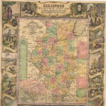
Permanent Collection - 1989.283.1
Color, illustrated map (formerly framed) "Illinois 100 Years Ago" depicts Illinois in 1834 and includes numerous insets illustrating events in both state and Chicago history. The 1834 map was drawn by J. H. Young and published in Philadelphia by Augustus Mitchell. Insets also provide a map of the lead mining region of northwest Illinois and southwestern Wisconsin, the population by sex of Illlinois counties, including the number of free colored...
Record Type: Archive
-
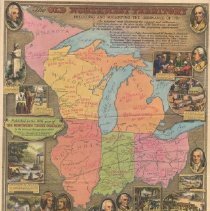
Permanent Collection - 1989.283.2
Color, illustrated map (formerly framed) of the Old Northwest Territory preceding and following the Ordinance of 1787 that created the Northwest Territory, showing areas of settlement by various Indian tribes, location of significant battles, forts and treaties, as well as major roads and rivers. Given as Christmas gift to customers in 1936 by The Northern Trust Company. The map includes numerous insets illustrating famous people and events rel...
Record Type: Archive
-
Permanent Collection - 1989.300
Map of the wooded area of Crow Island park showing bridle trails, foot trails, and wild flower locations. Hand drawn June 1940 by H. W. K. Shows the area between Sunset at the south and Mt. Pleasant to the west.
Record Type: Archive
-
Permanent Collection - 1989.95
Map of Winnetka, includes street names, subdivisions, land plots & acreage and plot dimensions. The map is mounted on board. The lower left corner is torn off; the lower right corner is torn off but is enclosed with the map.
Record Type: Archive
-
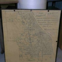
Permanent Collection - 1989.96
A map, mounted on hard board, of Chicago's North Shore communities noted in the title, showing streets, rivers, railroads and certain landmarks, such as golf clubs, forest preserves, Northwestern University, parks, etc. Has ringed holes for hanging. A note says the map has a washable surface and can be marked on with special oil pencils.
Record Type: Archive
-
Permanent Collection - 1990.53
Map of Winnetka and vicinity from Lake Michigan on the east to Northfield Township on the west, Jackson Ave (Glencoe) on the north to Avoca/Washington/Kenilworth Aves. on the south. Shows streets, subdivisions, and lots. The name Hill & Stone with offices in Wilmette, Winnetka and Highland Park is stamped on the map. A few penciled notations exist on the map.
Record Type: Archive
-
Permanent Collection - 1990.82
Distrist map of the village of Winnetka approved by the Winnetka Village Council January 17, 1922 as amended to January 2, 1935, dividing the village into the following districts: "A 1/2 Acre" Residence District, "A 1/6 Acre" Residence District,"B" Residence District, "C" Commercial District and "D" Industrial District.
Record Type: Archive
-
Permanent Collection - 1990.85.03
Winnetka village map showing house numbering grid and streets, subdivisions, parks, etc. Part of Irmgaid Graham's MA thesis (see 1990.85.01-.06).
Record Type: Archive
-
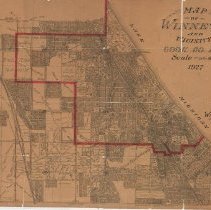
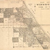
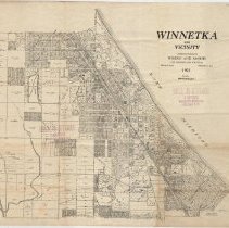
Permanent Collection - 1990.85.04
1927 Village Map of Winnetka and vicinity. Covers the area from Lake Michign on the east, Lake Street (Wilmette) on the south, Sunset Ridge Ave on the West and Jackson/Woodlawn (Glencoe) on the north. The map shows subdivisions, streets, lots, schools and other public building, parks, etc. Winnetka village limits are marked in red. Outlined in red pencil are the locations of several churches, parks and the Masonic Temple. The location of Eld...
Record Type: Archive